Free Shipping!
30-day Money Back Guarantee


-
- Item #14661
- PN: AKWPCZ
- In Stock
- Free Shipping!
- Item #14661
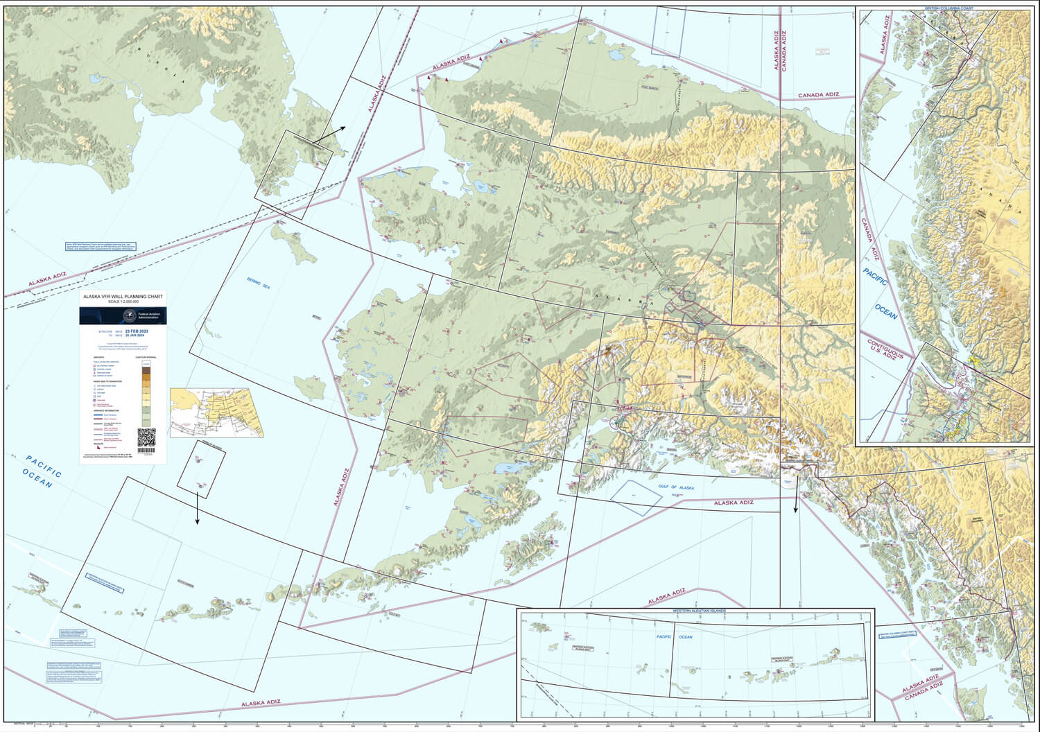
Alaska VFR Wall Planning Chart This chart is designed for VFR preflight planning and chart selection. It includes aeronautical and topographic information of the state of Alaska. The aeronautical information includes public and military airports; radio aids to navigation; and Class B, Class C, TRSA and special-use airspace. The topographic information includes city tint, populated places, principal roads, and shaded relief. The one sided chart is 58.5 x 40.75 inches and is designed for wall mounting and is delivered rolled in a tube.
Scale: 1:2,000,000. 27.4 natucial miles per inch.
SHIPPING INFORMATION: Price includes individual shipping rolled in a tube. If you are ordering other items, this will arrive in a second order by itself. All FAA VFR Wall Planning Charts are shipped via USPS Media Mail Service. UPS or FedEx shipping not available on this item.
IMPORTANT DATE NOTICE: The FAA discontinued updates to the VFR Wall Planning Chart effective January 22, 2026. All charts currently being sold display an expiration date of January 22, 2026 and must not be used for current navigation, flight planning, or operational purposes. These charts are sold for reference, educational, and decorative use only.
Lowest Price Guaranteed!

If you find a better price elsewhere on this product we will Match that price and beat it by 10% of the difference. See Details.
Buy with Confidence!

Purchase today and you can return it in the original condition through Wednesday, July 8, 2026! See our return policy.
- In Stock
- Free Shipping!
- Item #14661
- PN: AKWPCZ
FAA VFR Wall Planning Chart - Alaska Overview:
Alaska VFR Wall Planning Chart This chart is designed for VFR preflight planning and chart selection. It includes aeronautical and topographic information of the state of Alaska. The aeronautical information includes public and military airports; radio aids to navigation; and Class B, Class C, TRSA and special-use airspace. The topographic information includes city tint, populated places, principal roads, and shaded relief. The one sided chart is 58.5 x 40.75 inches and is designed for wall mounting and is delivered rolled in a tube.
Scale: 1:2,000,000. 27.4 natucial miles per inch.
SHIPPING INFORMATION: Price includes individual shipping rolled in a tube. If you are ordering other items, this will arrive in a second order by itself. All FAA VFR Wall Planning Charts are shipped via USPS Media Mail Service. UPS or FedEx shipping not available on this item.
IMPORTANT DATE NOTICE: The FAA discontinued updates to the VFR Wall Planning Chart effective January 22, 2026. All charts currently being sold display an expiration date of January 22, 2026 and must not be used for current navigation, flight planning, or operational purposes. These charts are sold for reference, educational, and decorative use only.
0 CUSTOMER REVIEWS
FAA VFR Wall Planning Chart - Alaska
0 Reviews
- Be the first to review this product!
1 QUESTIONS & ANSWERS
Previously Asked Questions
-
Saturday, October 28, 2023
Q: You call this a VFR Alaska map but it is no such thing. It is another lower 48 states map. Please fix it so I can order.
A: I''m not sure why you believe there is no Alaska Wall Planning chart. This indeed is a wall planning chart for Alaska.
If you want the Wall Planning Chart for the lower 48 United States, you can find that here.
Customers who bought this also considered:
Lowest Price Guaranteed!
If you find a better price elsewhere on this product we will match that price and beat it by 10% of the difference.
Buy with Confidence!
Purchase today and you can return it in the original condition through Wednesday, July 8, 2026 ! See our return policy.